Home Ignition Zones (HIZ) Mitigation Assistance Program (MAP)
Red Feather Lakes Area Wildfire Defense Project
Overview of Defensible Space and Home Ignition Zones (HIZ)
Firefighters always do their best to protect residents, but ultimately, it is your responsibility to protect your property and investments from wildfire.
Did you know? More than half of Colorado residents live in the wildland-urban interface and are at some risk of being affected by wildfire.
A main outcome of the Red Feather Lakes Area Wildfire Defense Project is the reduction of risk to properties through the performance of property assessments and subsequent defensible space treatments, and a robust community understanding of home ignition zone concepts and best practices through training and educational outreach. Improved community resilience through the building of Wildfire Partners Program ambassador teams and community social capital.
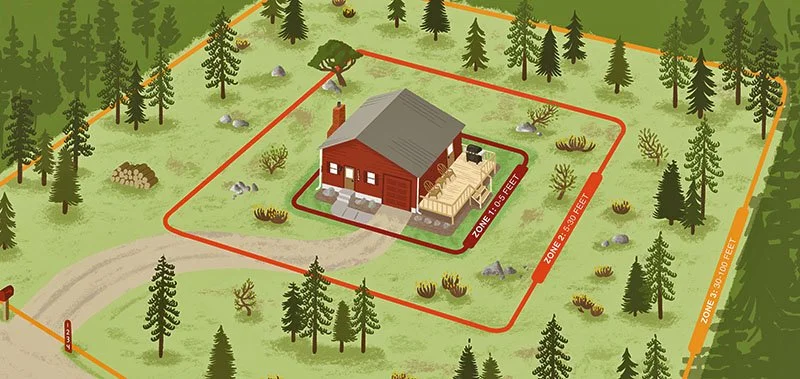
The Home Ignition Zone (HIZ) is the home and the area around the home (or structure). The HIZ takes into account both the potential of the structure to ignite and the quality of defensible space surrounding it.
Defensible space is the “area around a home or other structure that has been modified to reduce fire hazards. In this area, natural and manmade fuels are treated, cleared or reduced to slow the spread of wildfire (Colorado State Forest Service).”
By establishing defensible space, you can reduce the likelihood of your home igniting by direct contact with flame or by exposure to the radiant heat of a fire. It also helps limit local production of embers and reduces the chance a structure fire will spread to neighboring homes or surrounding vegetation.
What is HIZ MAP?
The Home Ignition Zone Mitigation Assistance Program (HIZ MAP) is an important component of the Red Feather Lakes Area Wildfire Defense Project. The HIZ MAP is designed to help move home ignition zone work forward on eligible and qualifying private properties by providing assistance through a structured program involving application, prioritization, property-specific work scope development, and contractor coordination and implementation.
HIZ MAP Application Process
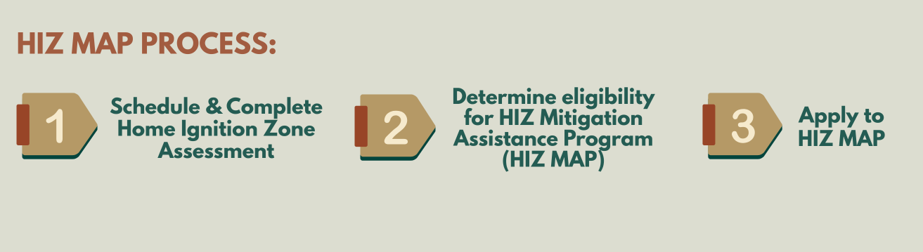
The HIZ MAP is intended to complement the Wildfire Partner Program (see below) and other wildfire mitigation efforts in the Project area. It is not only a mechanism for helping fund eligible defensible space work, but it is also intended to advance longer term shared stewardship, strengthen community understanding of wildfire risk and build capacity for sustained wildfire risk reduction over time.
Questions? Contact Kea Klug, HIZ Program Specialist, Larimer County Conservation Corps, at Klugkj@larimer.org
NOW ACCEPTING APPLICATIONS!

Schedule & Complete Home Ignition Zone Assessment (HIZA) with Your Local Fire Department
Request a Home Ignition Zone Assessment (HIZA) - choose your community below:
Glacier View Fire Protection District: Email gvfpd.faca@gmail.com with your name, the address of the property to be assessed, and your preferred times/days of the week. An Ambassador will contact you for scheduling.
If you are not sure whether you've had a HIZ Assessment done on your property, please email Klugkj@larimer.org
The HIZ MAP is intended to complement Larimer County’s Wildfire Partner Program, which provides tools, training and support for local fire departments to offer residents free, comprehensive wildfire HIZ Assessments. These Assessments are an educational experience for property owners, based on best practices and tailored to each unique property. They help homeowners better understand the wildfire risk around their homes and provide recommendations on actions they can take to reduce that risk. For the HIZ MAP, a completed HIZ Assessment is a prerequisite before a property can be considered for assistance.

Determine Eligibility for HIZ MAP
Geographic Area and Program Eligibility
The HIZ MAP is established for participating communities in the RFL Area Wildfire Defense Project, and as such, is available for qualifying private property within these Project areas, as defined in their respective Community Wildfire Protection Plans (CWPPs):
Cherokee Meadows
Crystal Lakes
Glacier View
Poudre Canyon
To be eligible for assistance through the HIZ MAP, the property/property owner:
Must be located within one of the four participating Project communities above
Be a privately owned developed parcel
Have a completed HIZ Assessment
Provide a signed Right of Entry
Eligible properties may include:
Primary owner-occupied residences
Secondary or seasonal residences
Renter-occupied residences
Other privately owned developed parcels
Not eligible to apply for HIZ MAP? That’s ok! A Home Ignition Zone Assessment (HIZA) is still encouraged, as it provides property owners with valuable direction and information about how to be wildfire ready. Learn more at the Larimer Sheriff’s Wildfire Partner Program >>

Apply to the HIZ MAP
The HIZ MAP is intended to assist moving work forward following the Home Ignition Zone Assessment. The HIZ MAP does this through a structured program that involves application, prioritization, property specific work scope development, and meaningful contractor implementation. Eligible community members can receive up to $4,000 worth of work for wildfire mitigation on qualifying properties within the project areas.
Important Info:
Before applying, please make sure you have a completed Home Ignition Zone Assessment through your local fire protection district.
Applying for the HIZ MAP does not guarantee assistance, funding or work on your property.
This program supports eligible defensible space and vegetation-management work. This program does not pay for home-hardening improvements such as roofing, vents, screens, gutters, or other building-related upgrades.
If your property is selected, a Program Specialist will work with you to develop and review the final scope of work for your property before any work begins.
Need a PDF version of the application? Please email Kea Klug, HIZ Program Specialist, Larimer County Conservation Corps, at Klugkj@larimer.org
HIZ MAP Webinar - June 8, 6-8pm
Learn more about the Home Ignition Zone Mitigation Assistance Program (HIZ MAP) during this informational webinar. The webinar will provide an overview of the program, rules regarding eligibility, the application process, property prioritization considerations, and what selected property owners can expect if they receive assistance. We will also walk through the application portal and answer common questions. Eligible property owners in the Red Feather Lakes Area Wildfire Defense Project communities are encouraged to attend.
Defensible Space and Home Ignition Zones (HIZ) Resources
The Home Ignition Zone: A guide to preparing your home for wildfire and creating defensible space (Colorado State Forest Service)
Wildfire Partners Program (Larimer County Sheriff’s Office)
Wildfire Mitigation Tax Credit Form (State of Colorado)

Reducing and spacing fuels (trees, vegetation, and debris) can keep a wildfire on the ground near homes, where it is less likely to ignite structures. The home ignition zones are defined as the distance from a home with specific types of landscaping recommendations. Photo credit: Tri County Fire Safe Working Group