Elkhorn Creek at the Scout Ranch
Low-Tech Process-Based Restoration
This project will seek to address impacts to the Elkhorn Creek stream corridor caused by historical grazing, loss of beaver, and disturbance from the 2020 Cameron Peak Fire.
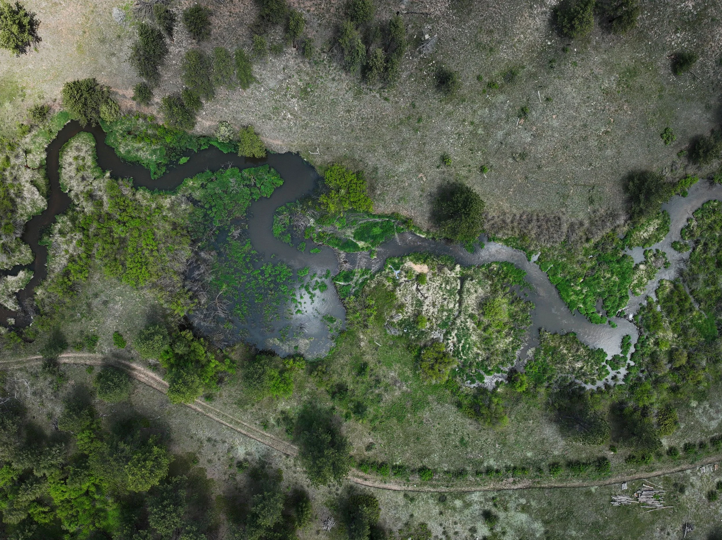
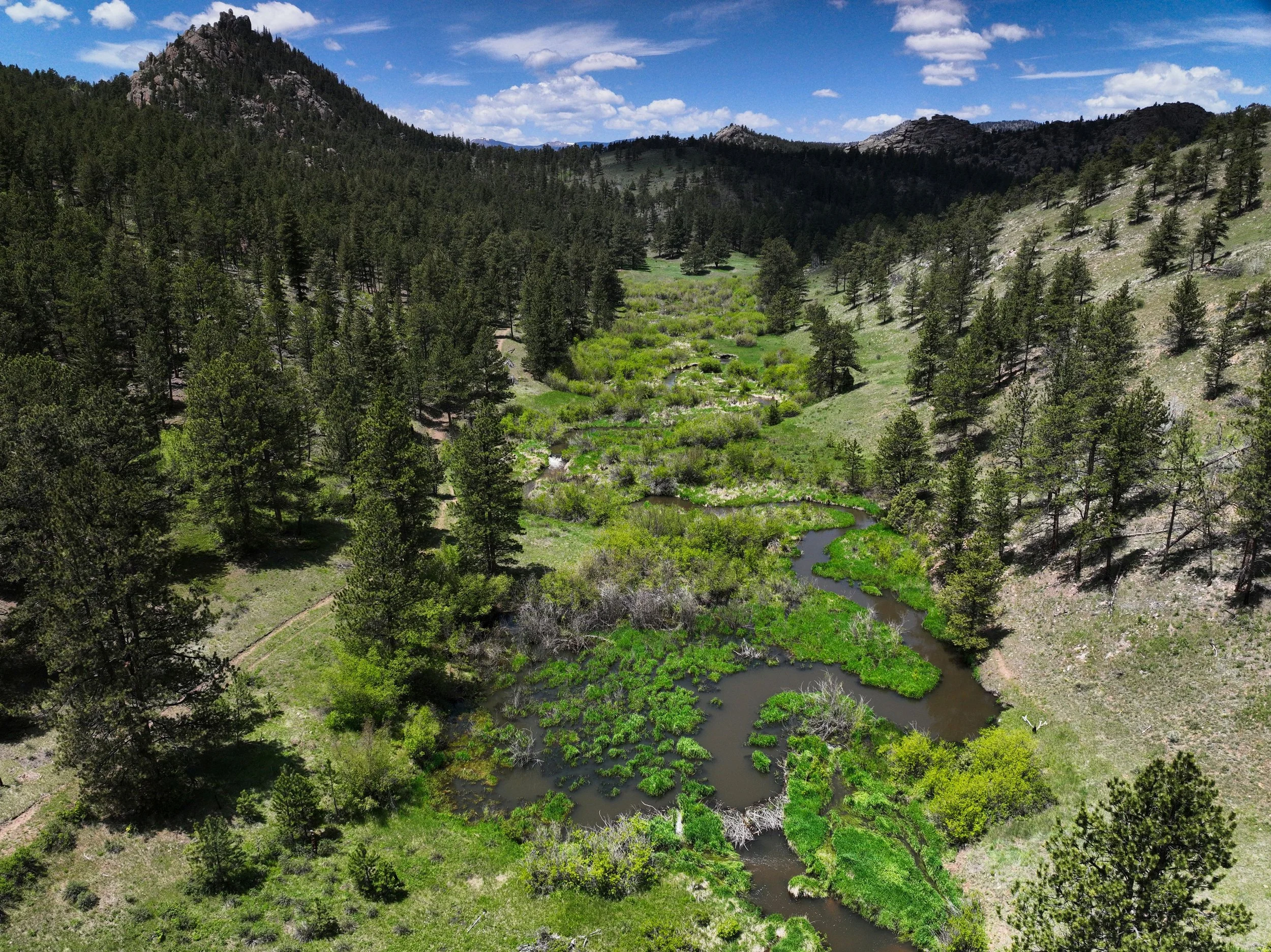
An aerial view of Elkhorn Creek as it runs through the Ben Delatour Scout Ranch in Red Feather Lakes, CO.
Project Overview
The Larimer Conservation District (LCD) and Coalition for the Poudre River Watershed (CPRW) have partnered to restore 3 miles of Elkhorn Creek, a priority stream for restoration identified by CPRW’s Upper Poudre Resilience Master Plan. This project will seek to address impacts to the Elkhorn Creek stream corridor caused by historical grazing, loss of beaver, and disturbance from the 2020 Cameron Peak Fire using low-tech process-based restoration (LTPBR) and riparian revegetation to improve the geomorphic and hydrologic functionality of the stream and its surrounding floodplain.
The proposed project location encompasses ~3 miles of the mainstem of Elkhorn Creek flowing through Ben Delatour Scout Ranch (BDSR). The 2020 Cameron Peak Fire heavily impacted the DMC property, severely burning all riparian vegetation. Though the BDSR property was unburned, the increased sediment loading and altered hydrology has further degraded this reach, leading to additional incision and further disconnecting the stream from its floodplain.
LTPBR will be used to achieve the following project goals: 1) reconnect Elkhorn Creek to its floodplain to enhance stream complexity, improve wildlife habitat and increase resiliency to future disturbances and 2) engage with the public to increase knowledge and understanding of resilient watersheds.
Project Area
Click to enlarge map.
Click to enlarge map.
Treatments
Post Assisted Log Structure (PALS) – On-site woody material of various sizes is stabilized using untreated posts driven into the streambed to initiate and simulate natural wood accumulation. PALS provide opportunity for sediment storage behind the structures while promoting floodplain connectivity, additional wood recruitment, and riparian health. These features will be field fit by the design team.
Beaver Dam Analogue (BDA) – BDAs are channel-spanning, permeable structures with a uniform crest elevation constructed using woody debris and fill material to form a pond and mimic natural beaver dams (Wheaton et al., 2019). Woody material and sediment plugs are gathered on-site and matted together in layers to create a wide berm. Posts may be driven through the structure after reaching the final crest height in order to provide additional stability. BDAs mimic the form and function of natural beaver dams by creating a large backwater area behind the structure, which benefits habitat and floodplain connectivity. These features will be field fit by the design team.
Riparian Plantings - Recovery of riparian ecosystems is vital to improving water quality. Establishing woody riparian vegetation such as cottonwoods, willows, and other native plants increases the capacity for sediment storage and nutrient uptake and enhances habitat complexity in riparian and aquatic ecosystems. Narrowleaf cottonwoods and willows were gathered off-site and either planted as cuttings or as containerized stock after being grown in a greenhouse. Plants were installed at locations with shallow water tables that will support establishment and continued colonization. Relative elevation models were used to identify feasible planting locations. Mass plantings of cottonwoods will restore gallery forest patches that are now scarce within the watershed. Willows were planted near in-channel and floodplain mitigation features to provide additional hydraulic roughness and structure stability.
Wildlife Exclusion Fencing - Fencing will be installed in select areas to protect expanding riparian vegetation from heavy browsing pressure from large wildlife ungulates (moose and elk) until vegetation can get established above browse height. This fencing will allow for expansion of existing vegetation into newly wetted areas.
Weed Treatment - Riparian vegetation is pressured by invasive species (i.e. weeds) and therefore weed treatment will be utilized to reduce this plant pressure and support the return of a strong and diverse native plant population.
These structures will help restore hydrology, reconnect the stream to its floodplain, encourage frequent over-bank flow in high-flow scenarios, and increase diversity of habitat features such as ponds. LTPBR structures will also be installed strategically to restore the balance of fluvial processes (erosion, transport, and deposition of sediment) and to encourage expansion of existing beaver activity, filling in gaps or barriers they have to movement based on a lack of suitable habitat features.
Project Goals
To address the management goals of BDSR's conservation easement and Landowner Forest Stewardship Plan, as well as LCD’s Forest Management Plan (FMP) for the property (developed when LCD was previously known as Fort Collins Conservation District)
To restore this reach to a geomorphological state and riparian vegetation composition that better reflects the historic and natural structure and function inherent to the long-term success of these systems and local wildlife.
To compliment the 10 years of forestry work implemented on the property because it expands on the reduction of risk of wildfire and forest habitat improvements to riparian habitat restoration, overall increasing the landscape-scale resiliency of the property and watershed.
Project Collaborators
Coalition for the Poudre River Watershed (CPRW)
Ben Delatour Scout Ranch
Funder(s)
Colorado Water Conservation Board (CWCB)
Biophilia Foundation
The Nature Conservancy
NRCS Environmental Quality Incentives Program (EQIP)
Great Outdoors Colorado (GOCO)
Mossy Earth
Project Timeline
Summer 2026